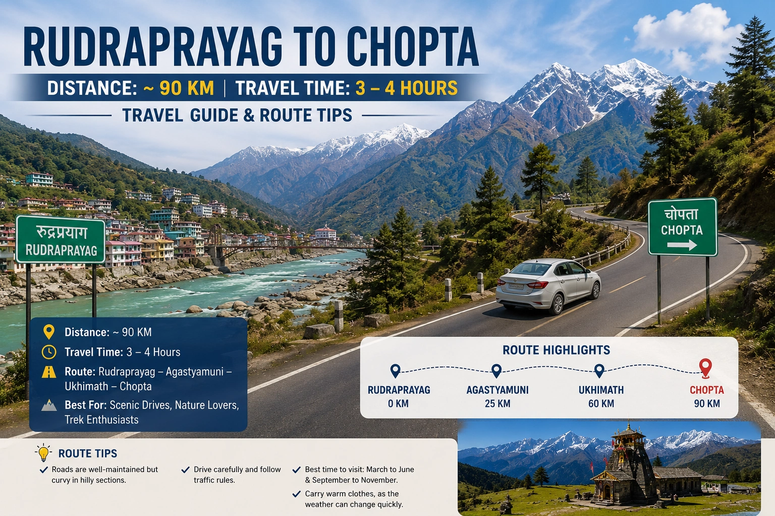
The road distance from Rudraprayag to Chopta is approximately 83–92 kilometres, depending on your route, and takes 3 to 4 hours by road under normal road conditions. The most common route runs via Agastmuni and Ukhimath on State Highway 109. This guide covers every practical detail you need — transport, timing, altitude prep, and what actually to expect on the ground.
Introduction: Why This Route Trips People Up
Most of the travellers treat Rudraprayag as just a connecting point — somewhere you pass through on the way to Kedarnath. That’s a mistake. For anyone heading to Chopta and Tungnath, Rudraprayag is actually your last town where Petrol, ATMs, pharmacies, a warm meal before the final climb — it all lives here. Once you leave Agastmuni and start gaining altitude past Ukhimath, the road thins.
This guide is for the traveller who wants the actual numbers, the real road conditions, and the kind of tips that only come from having done this route more than once.
Rudraprayag to Chopta Distance: The Numbers
Distance by road: 83 km to 92 km (varies by GPS and exact drop point in Chopta) Chopta to Rudraprayag distance (return): Same route, approximately 85–90 km Rudraprayag to Chopta Tungnath distance (trailhead): Add 1.5 km on foot from Chopta motorable road-end to the Tungnath temple base
Elevation gain context: Rudraprayag sits at roughly 895 metres. Chopta is at 2,680 metres. You’re climbing nearly 1,800 metres in under 90 km of road. That gradient is why the drive feels longer than the kilometre count suggests, and why cars with weak engines or worn brakes have no business on this road.
The Route Breakdown: Rudraprayag to Chopta by Road
The Primary Route: Via Agastmuni and Ukhimath
This is the standard route and the one all local taxi drivers default to.
Rudraprayag → Agastmuni → Kund → Ukhimath → Duggalbitta → Chopta
- Rudraprayag to Agastmuni: 15 km, flat road along the Mandakini valley, easy 25–30 minutes
- Agastmuni to Kund: 18 km, road begins to wind, gradient picks up
- Kund to Ukhimath: 12 km, narrow in patches, some hairpin sections
- Ukhimath to Duggalbitta: 25 km, dense forest, heavy fog possible after October
- Duggalbitta to Chopta: 10 km, final climb, road surface deteriorates in monsoon
Total: ~80–83 km from the Rudraprayag town centre to Chopta.
The Alternative Route: Via Tilwara (Sonprayag side)
Some drivers go via Tilwara–Okhimath if there’s a road block or landslide on the main highway. This adds roughly 15–20 km and is rarely recommended unless forced. Don’t take this route without confirming road status at Rudraprayag itself.
Common Mistake: Many travellers check Google Maps from the comfort of their hotel and see “2.5 hours” to Chopta. That estimate assumes smooth, uninterrupted roads. Between Kund and Ukhimath, construction delays, one-way traffic restrictions, and debris-clearing trucks are routine, especially June through September. Budget 3.5 to 4 hours as your baseline.
Transport Options: Getting from Rudraprayag to Chopta
Shared Jeep / Sumo
Shared jeeps from Rudraprayag to Ukhimath run fairly regularly from the bus stand area in the morning. From Ukhimath, you’ll need a second vehicle to Chopta since direct shared transport is rare beyond that point.
Fare estimate: ₹100–₹150 per seat to Ukhimath. From Ukhimath to Chopta, shared options cost ₹80–₹120 per person if you can find a vehicle.
This is the cheapest option but requires flexibility and some patience at Ukhimath.
Private Taxi: The Reliable Choice
How much is a taxi from Rudraprayag to Chopta?
A private taxi from Rudraprayag to Chopta costs ₹2,000–₹3,500 for a one-way trip, depending on vehicle type and whether you’re booking through a hotel, directly with a driver, or via an app. Innova or similar SUVs run at the higher end. A Bolero or Scorpio can be negotiated down, especially off-season.
For the return leg (Chopta to Rudraprayag), rates are similar. Book your return taxi in advance — stranded at Chopta with no vehicle is not a minor inconvenience at 2,680 metres.
Local’s Tip: Hire your taxi from Rudraprayag directly at the stand near the main chowk rather than through your hotel. Hotel-arranged taxis carry a 20–30% markup. Ask for drivers who “regularly go Ukhimath side” — they know which sections of road are currently rough and time their departure accordingly.
By Own Vehicle / Car

Can we go to Chopta by car?
Yes, you can drive to Chopta by car. The road is motorable all the way to the Chopta meadow area. A standard hatchback can manage in dry conditions from October to May. Beyond Ukhimath, the road narrows and some stretches are unpaved or patchy, so a higher ground clearance vehicle (Ertiga, Scorpio, Bolero, Innova Crysta) is a practical advantage rather than a luxury.
Fuel up at Rudraprayag if you’re starting from there — but don’t stress if you miss it. There is a petrol pump in Agastmuni (roughly 15 km from Rudraprayag) and another in Ukhimath. Both are functional and serve the Chopta-bound traffic regularly. That said, don’t assume either will be open late evening or during bandhs — top up whenever you see an opportunity rather than waiting for the “right” stop.
Altitude, Acclimatization, and What 2,680m Actually Feels Like
At 2,680 metres, Chopta doesn’t cross the threshold that triggers serious altitude sickness in most healthy adults. But you climbed from under 900 metres in a few hours. The rapid gain matters more than the absolute height.
If you’re coming from the plains and arrived in Rudraprayag the same day, give yourself a rest stop of at least 30 minutes in Ukhimath Omkareshwar temple (elevation: roughly 1,300 metres). Eat something, hydrate, and notice how you feel. Headache and mild breathlessness on arrival at Chopta is normal. Persistent headache after 4–6 hours, nausea, or disorientation is your signal to descend immediately — not the next morning.
The Tungnath trek itself starts at Chopta and climbs another 1,000+ metres to approximately 3,680 metres. Rudraprayag to Chopta Tungnath as a same-day itinerary — arriving in Chopta, trekking to Tungnath, returning — is only realistic if you started from Rudraprayag before 7 AM and are physically fit. Anyone starting after 9 AM should plan to either stay overnight at Chopta or skip the Tungnath trek entirely for that day.
Common Mistake: Assuming the 1.5 km trek to Tungnath is a casual walk because the distance sounds small. The trail gains roughly 800–900 metres of elevation. It takes 2 to 3 hours round trip for a moderately fit person who isn’t acclimatized. Factor that in honestly.
When to Go: Seasonal Reality Check
Which month is best for Chopta?
- April to June: This is the prime window. The snow from winter has partially cleared from the Tungnath trail by late April, the rhododendrons are out, and the temperature at Chopta ranges from 5°C nights to 15°C afternoons. The road from Rudraprayag is fully operational.
- September to November: The second-best window. Post-monsoon clarity means long views. October is particularly good — crisp air, minimal crowds compared to peak summer. The road is stable again after monsoon repairs.
- December to March (Winter): Chopta itself can be accessible, but the Tungnath trail may be under heavy snow. Temperatures drop to -10°C or lower at night. Does Tungnath get very cold? Yes — brutally so. The temple itself closes officially after Diwali (around October–November), so a winter visit means the temple is shut. Go only if you’re equipped for sub-zero camping conditions or if you’re after the snow landscape specifically.
- July to August (Monsoon): The road between Ukhimath and Chopta is prone to landslides, especially near Baniyakund and Duggalbitta. Travel is possible but you should check SDRF (State Disaster Response Force) road status reports the morning of your trip. Delays of 2–5 hours at a single blockage are common.
Is there snowfall at Tungnath? Regular snowfall from December through February. The trail can see snow as early as November and as late as April at the upper stretches. The snowfall at Tungnath is among the heaviest of any motorable-adjacent trek in Uttarakhand — plan accordingly if you’re there in the shoulder months.
Chopta: What It Is and Why People Go
What is Chopta famous for?
Chopta is the base for the Tungnath–Chandrashila trek circuit. Tungnath is the highest Shiva temple in the world at 3,680 metres, part of the Panch Kedar pilgrimage circuit. Chandrashila, a further 1 km above Tungnath, gives 360-degree views of Nanda Devi, Trishul, Kedarnath, and Chaukhamba peaks.
Beyond the trek, Chopta itself is a meadow — open pastureland surrounded by oak and rhododendron forest. It’s quiet, especially on weekdays. There’s no town, no market worth mentioning, and no hospital. That simplicity is the point.
Is Chopta in Rudraprayag district? Yes. Chopta falls within the Rudraprayag district of Uttarakhand, in the Kedarnath Wildlife Sanctuary buffer zone.
Chopta vs. Auli: A Practical Comparison
Which is better, Auli or Chopta?
They serve entirely different purposes, so the comparison only makes sense if you specify what you want.
Auli (Chamoli district) is a ski resort with a gondola, hotels, and infrastructure for casual tourism. It’s accessible, well-connected from Joshimath, and oriented around winter sports and comfort.
Chopta has none of that. No gondola, minimal accommodation, no ski slopes. What it has is a serious trek to a high-altitude temple, dense wildlife sanctuary surroundings, and significantly fewer crowds than Auli.
If you’re going for a comfortable hill station weekend: Auli. If you’re going to trek Tungnath and experience a high Himalayan meadow without the resort packaging: Chopta. They’re different categories of place.
Accommodation at Chopta: Honest Expectations
What is the cost of a hotel in Chopta?
“Hotel” is a loose word at Chopta. What you’ll find are basic guesthouses, GMVN (Garhwal Mandal Vikas Nigam) tourist rest houses, and seasonal tented camps.
- Budget guesthouses: ₹500–₹1,200 per night for a basic room with attached or shared bathroom. Hot water is usually bucket hot water, not geysers.
- GMVN rest house: ₹1,000–₹2,000 per night; bookable in advance through the GMVN website or district tourism office.
- Tented camps: Seasonal (typically April–June and September–November), ₹2,000–₹4,000 per night including meals.
Book in advance for April–June. During peak season, Chopta’s limited accommodation fills up quickly and there’s no viable backup option nearby.
Local’s Tip: If every guesthouse at Chopta is full, Duggalbitta (10 km before Chopta) has two or three dhabas with basic rooms. Not comfortable, but functional as a last resort.
Chopta and the “Mini Switzerland” Question
Is Chopta Mini Switzerland? Where is Mini Switzerland in Uttarakhand?
The “Mini Switzerland” label gets applied to several places in Uttarakhand — Chopta, Khirsu, and Chakrata all claim it. It’s a marketing phrase, not a geographic one. Chopta’s meadow terrain and alpine tree line do produce a visual similarity to Swiss alpine landscapes, which is where the comparison comes from.
What the comparison actually tells you: expect open grassland at elevation, surrounded by conifer and rhododendron forest, with clear snow-peak views on good-weather days. That’s accurate. Everything else about the label is tourism shorthand you can disregard.

Quick Reference: Key Distances from Chopta
|
Route |
Distance |
Approx. Time |
|
Rudraprayag to Chopta by road |
83–92 km |
3–4 hours |
|
Chopta to Ukhimath |
~40 km |
1.5 hours |
|
Chopta to Tungnath (trek) |
3.5 km one way |
2–3 hours up |
|
Chopta to Chandrashila (trek) |
5 km one way |
3–4 hours up |
|
Chopta to Haridwar |
~230 km |
7–8 hours |
|
Nainital to Chopta distance |
~285–310 km via Almora / Pauri |
9–11 hours |
Kedarnath Tourism, based in Ukhimath, handles taxi services and tour packages for the Chopta–Tungnath circuit. Because they’re based locally — not in Rishikesh or Dehradun — their drivers know the Ukhimath–Chopta road in all conditions: post-monsoon debris, winter snow patches, the stretches that get icy before dawn. That local knowledge is not something a city-based aggregator can replicate.
Frequently Asked Questions
How much is a taxi from Rudraprayag to Chopta?
₹2,000–₹3,500 for a private taxi depending on vehicle type and booking source. Shared transport is available to Ukhimath for ₹100–₹150 per seat, with a second vehicle needed from Ukhimath onwards.
Which city is closest to Chopta?
Ukhimath, roughly 40 km away, is the nearest town. For a larger city, Rudraprayag (85–90 km) is the closest functional base with ATMs, pharmacies, and fuel.
Can we go to Chopta by car?
Yes. The road is motorable to the Chopta meadow. A higher ground-clearance vehicle is more practical. Fuel up in Rudraprayag — there’s no reliable pump between there and Chopta.
Which is better, Auli or Chopta?
Different categories. Auli suits resort-style tourism and skiing. Chopta suits trekkers and pilgrims targeting Tungnath/Chandrashila. Choose based on what you’re actually going for.
Where is Mini Switzerland in Uttarakhand?
The label is applied to Chopta, Khirsu, and Chakrata interchangeably. It refers to open alpine meadows with snow-peak backdrops — not an official designation.
Which month is best for Chopta?
April–June (first window, rhododendrons and clear trails) and October–November (post-monsoon, clear skies, fewer visitors) are the two optimal windows.
How far is Nainital from Chopta?
Approximately 285–310 km depending on route. Via Pauri or Almora, expect 9–11 hours of travel. Not a same-day connection without very early starts.
Is Chopta in Rudraprayag district?
Yes. Chopta is within Rudraprayag district, inside the Kedarnath Wildlife Sanctuary buffer zone.
What is the cost of a hotel in Chopta?
₹500–₹1,200 for basic guesthouses. GMVN rest house: ₹1,000–₹2,000. Tented camps (seasonal): ₹2,000–₹4,000 including meals.
How to reach Rishikesh to Rudraprayag?
142 km via NH58/NH7, roughly 4–5 hours. Regular buses from Rishikesh ISBT, and shared jeeps from Shyamnagar stand. Private taxis cost ₹2,500–₹4,000.
Why is Rudraprayag famous for?
The confluence (prayag) of the Alaknanda and Mandakini rivers. It’s a sacred Hindu site and a key logistics stop on routes to Kedarnath and Chopta. It also carries the historical distinction of the “Rudraprayag leopard” made famous by Jim Corbett’s book.
Does Tungnath have snowfall?
Yes, heavy snowfall from December through February. Snow is possible on the upper trail from November through April. The Tungnath temple officially closes after Diwali.
Does Tungnath get very cold?
Temperatures at Tungnath (3,680 m) drop below -10°C in January–February. Even in October, post-sunset temperatures at Chopta fall to 2–5°C. Thermal layers and a wind-proof outer shell are not optional.
Which is the coldest place in Uttarakhand?
Mana village near Badrinath (3,200 m) and Munsiyari in Pithoragarh district are consistently among the coldest inhabited places. High-altitude passes like Niti Pass and Roopkund area record the most extreme cold. Chopta is cold but not among the most extreme.


