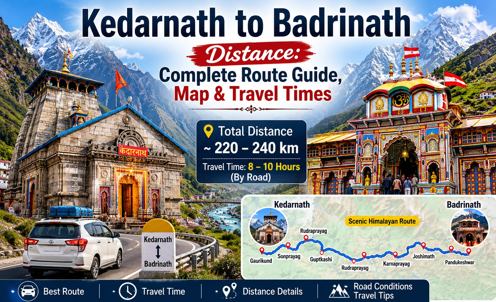
The actual road distance between Kedarnath and Badrinath is 218 kilometers when traveling via the Chopta route from the Sonprayag roadhead, requiring approximately 8 to 10 hours of active mountain driving. If you travel via the alternative Rudraprayag highway, the road distance increases to 230 kilometers and takes 10 to 11 hours. There is no direct highway connecting the two shrines; travelers must descend from the Kedarnath mountain ridge into the Mandakini valley before ascending the Alaknanda valley to reach Badrinath.
What is the Distance Between Kedarnath and Badrinath?
When planning your journey across the Char Dham circuit, understanding the distinction between geographical distance and actual on-the-road mileage is critical. The high-altitude mountain geography of Uttarakhand prevents any direct, straight-line highways between the two temples.
Geographical vs. Road Distance
- Aerial Distance: The straight-line distance between Kedarnath and Badrinath is only 41 kilometers (25 miles). High-altitude mountain ridges and deep gorges make a direct road connection impossible.
- Actual Road Distance: The real-world Kedarnath to Badrinath distance by road is 218 kilometers (135 miles) starting from Sonprayag, which serves as the primary vehicular hub for Kedarnath.
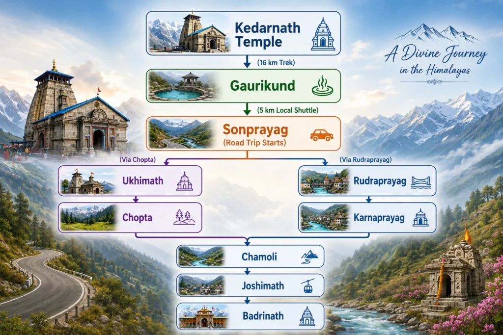
- Trek Distance: You must factor in the mandatory 16-kilometer foot trek from the Kedarnath Temple down to the Gaurikund motor-head before your road journey even begins.
Comprehensive Route Comparison Table
|
Route Parameter |
Route 1: Via Chopta (Shorter & Scenic) |
Route 2: Via Rudraprayag (All-Weather Highway) |
|
Total Distance |
218 Kilometers |
230 Kilometers |
|
Average Drive Time |
8.5 to 9.5 Hours |
10 to 11 Hours |
|
Road Classification |
State Highway & District Roads |
National Highway (NH 58 & NH 107) |
|
Maximum Altitude |
2,680 meters (at Chopta Pass) |
1,879 meters (at Joshimath) |
|
Key Choke-Points |
Kund slip zones, Chopta forest curves |
Sirobagarh landslide zone, Helang bypass |
|
Best Used For |
Fast daytime transit, scenic mountain views |
Monsoon travel, heavy vehicle transit |
Kedarnath to Badrinath Road Distance & Route Breakdown
To safely navigate the distance between Kedarnath and Badrinath, you have two primary road options. Both routes begin at Sonprayag (the vehicle parking lot below Gaurikund) and terminate at the Badrinath Temple entrance.
Route 1: The Chopta Route (218 km) — Recommended
This is the fastest and most visually stunning route. It takes you through the high-altitude meadows of Chopta, offering a direct cut-off that bypasses the southern river confluences.
- Detailed Route Map: Sonprayag → Guptkashi → Kund → Ukhimath → Chopta → Mandal → Chamoli → Pipalkoti → Helang → Joshimath → Govindghat → Pandukeshwar → Badrinath.
- Key Road Stages & Distances:
- Sonprayag to Kund (37 km): Decent tarmac, gradual descent along the Mandakini River.
- Kund to Ukhimath to Chopta (34 km): Narrow, steep mountain road climbing through dense forests. Roads can be slippery during early morning frost.
- Chopta to Chamoli via Mandal (50 km): Sharp hairpin bends. Demands experienced mountain driving skills.
- Chamoli to Badrinath (97 km): Joins the Badrinath National Highway (NH 58). Mostly double-lane highway, but prone to localized rockfalls.
Route 2: The Rudraprayag Route (230 km) — Backup Highway
This route is longer but stays on wider national highways for a larger portion of the trip. It is the preferred route for large traveler buses and heavy vehicles.
- Detailed Route Map: Sonprayag → Phata → Guptkashi → Kund → Agastyamuni → Rudraprayag → Karnaprayag → Langasu → Nandaprayag → Chamoli → Pipalkoti → Joshimath → Badrinath.
- Key Road Stages & Distances:
- Sonprayag to Rudraprayag (74 km): Follows the NH 107. Expect moderate traffic near Phata due to helipads.
- Rudraprayag to Chamoli (60 km): Smooth driving along the Alaknanda River on NH 58. This stretch is well-stabilized but busy.
- Chamoli to Badrinath (96 km): Steady climb with gradual altitude increase.
Kedarnath to Badrinath Distance by Road Time & Transport Logistics
Covering the Kedarnath to Badrinath road distance in a single day requires careful planning. Average speeds in the Himalayas rarely exceed 25 to 30 km/h due to steep gradients, sharp curves, and localized traffic delays.
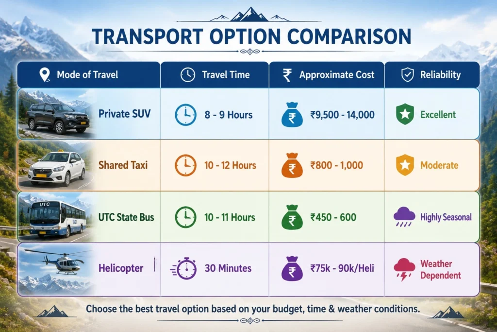
1. Traveling by Private Cab / SUV
- Best Vehicle Options: Toyota Innova, Mahindra Bolero, or Tata Sumo. Low-clearance hatchbacks are not recommended.
- Average Cost: ₹9,500 to ₹14,000 for a one-way drop depending on the vehicle class.
- Time Required: 8 to 9 hours of clean driving.
- Pro-Tip: Book local drivers from the Sonprayag or Guptkashi taxi unions. They have specialized experience handling local terrain and landslide zones.
2. Traveling by Public and Shared Transport
- Direct Bus Service: The Uttarakhand Transport Corporation (UTC) and GMOU run limited direct buses between Guptkashi/Sonprayag and Badrinath during the peak pilgrimage season (May to October).
- Shared Jeeps: You can travel in stages. Take a shared Jeep from Sonprayag to Rudraprayag, change for another Jeep to Chamoli/Joshimath, and catch a final local shuttle to Badrinath.
- Cost Factor: Extremely economical. Bus tickets cost around ₹450 to ₹600 per passenger. Shared Jeeps cost approximately ₹800 to ₹1,000 in total for all legs.
3. Traveling by Helicopter (Charter & Heli-Tourism)
- How It Works: While there is no direct commercial shuttle landing inside the Badrinath temple complex from Kedarnath, private operators offer chartered helis.
- Route: Helipads in Sersi, Phata, or Guptkashi fly directly to the Badrinath Helipad (located near the army camp).
- Transit Time: Just 25 to 30 minutes of flight time.
- Cost: Packages start at approximately ₹75,000 to ₹90,000 per charter slot or are sold as part of premium 2-Dham heli-packages.
Local Insider Ground Realities & Mountain Choke-Points
Standard mapping services do not show real-time mountain hazards. To navigate the distance between Badrinath and Kedarnath safely, you must plan around the following logistical challenges.
1. Critical Landslide & Traffic Choke-Points
- Sirobagarh (NH 58): Located between Srinagar and Rudraprayag. Even light rains can trigger falling stones here, causing multi-hour traffic delays. If Sirobagarh is blocked, use the alternative route via Mayali.
- Helang Bypass: This zone is highly prone to highway widening work and soil instability. Expect controlled blasting delays between 11:00 AM and 2:00 PM.
- Lambagarh Slip Zone: Historically the most dangerous stretch before Badrinath. While the newly engineered protective canopy has minimized major blockages, drive with high caution during rains.
2. Night Driving Restrictions
- The 8 PM Rule: The Uttarakhand Police and local authorities prohibit commercial and private passenger vehicle movement on the ghat roads of the Char Dham circuit after 8:00 PM.
- Implication: You must reach your destination town (either Joshimath/Badrinath or Guptkashi/Sonprayag) before nightfall. Plan to depart no later than 7:00 AM.
3. Permit and Checkpoint Protocols
- Biometric Registration: All travelers must carry a valid Char Dham Yatra Registration card (physical printout or QR code on mobile).
- Check-posts: Keep your registration papers handy at the Sonprayag exit gate, Kund barrier, and Joshimath entry point. Drivers must verify green cards (temporary permits for commercial vehicles inside hills).
Optimizing Your Itinerary: Recommended 2-Day and 3-Day Transits
Attempting to complete the 16 km trek down from Kedarnath and immediately drive the 218 km road distance to Badrinath on the same day is dangerous. Fatigue increases transit risk on narrow mountain roads. Use these structured itineraries instead.
Option A: The Recommended 3-Day Transit (Balanced & Safe)
- Day 1: Kedarnath to Sonprayag to Guptkashi
- Start your trek down from Kedarnath Temple at 6:00 AM.
- Reach Gaurikund/Sonprayag by 12:00 PM.
- Drive 30 km to Guptkashi. Check into a local hotel, rest, and acclimatize.
- Day 2: Guptkashi to Badrinath via Chopta (188 km)
- Depart Guptkashi by 6:30 AM.
- Cross the scenic Chopta Pass by 9:00 AM (ideal for stopping to take photos before clouds roll in).
- Reach Joshimath for a quick lunch at 1:30 PM.
- Arrive at Badrinath by 4:00 PM. Attend the evening Maha Aarti at the temple.
- Day 3: Badrinath Darshan & Return Journey
- Complete early morning temple Darshan.
- Drive down to Rishikesh/Dehradun or head to your next destination.
Option B: The Express 2-Day Transit (For Experienced Travelers)
- Day 1: Kedarnath Trek Down & Afternoon Drive to Pipalkoti
- Depart Kedarnath Temple by 5:00 AM.
- Reach Sonprayag by 11:00 AM.
- Immediately board your vehicle and drive via the Chopta route.
- Push through to Pipalkoti (approx. 140 km from Sonprayag). Halt for the night.
- Day 2: Pipalkoti to Badrinath (78 km)
- Start driving at 6:00 AM.
- Avoid peak morning traffic at Joshimath.
- Arrive in Badrinath by 9:30 AM for morning prayers.
Frequently Asked Questions
Can I travel from Kedarnath to Badrinath in a single day?
Yes, but only if you are starting your journey from the roadhead at Sonprayag/Guptkashi early in the morning. If you are starting from the Kedarnath Temple itself, you cannot complete the 16-kilometer trek and the 218-kilometer drive to Badrinath in one calendar day due to night driving bans on the hills.
Which is the better route: via Chopta or via Rudraprayag?
The Chopta route is better for light vehicles, SUVs, and travelers looking to save 1 to 2 hours of travel time. The Rudraprayag route is better for large family buses, travelers seeking wider roads, or anyone traveling during heavy monsoon rains when the high-altitude pass at Chopta can experience soil slips.
What are the road conditions between Badrinath and Kedarnath?
The road conditions are generally fair to good, consisting of double-lane highways (under the Char Dham All-Weather Road Project) for about 70% of the journey. The remaining 30% consists of narrow, single-lane stretches around Chopta, Mandal, and local bypass roads where construction is still active.
Are there petrol pumps along the Kedarnath to Badrinath route?
Yes. You will find reliable, functional petrol pumps at Guptkashi, Kund, Ukhimath, Chamoli, Pipalkoti, and Joshimath. There are no petrol pumps in Chopta itself, and the pump at Badrinath can occasionally run out of stock during peak crowds, so fuel up at Joshimath.
Plan Your Chardham Journey with Local Experts
Navigating the roads between Kedarnath and Badrinath requires more than just looking at GPS coordinates. Landslides, variable weather, and local high-altitude driving conditions demand careful preparation and reliable transportation.
At Kedarnath Tourism, we provide end-to-end travel logistics for the complete Char Dham circuit. Our regional network offers:
- Verified Mountain Drivers: Highly experienced local drivers specializing in the Chopta and Joshimath ghat roads.
- Custom Tour Packages: Tailored 2-Dham and 4-Dham itineraries featuring pre-booked accommodations, VIP Darshan assistance, and biometric registration support.
Real-Time Route Updates: Daily updates on road conditions, landslide clearances, and weather-driven administrative advisories.

